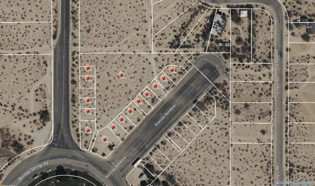
0 Town Center Christmas Circle
DdirtBorrego Springs, CA 92004
Lot Size
2.29 acres
Asking $/Acre
$217,905
Days on Market
45
Property Type
Land
HOA/mo
N/A
MLS ID
260024139SD
This property is in Borrego Springs (92004). View the Borrego Springs land market →
About This Property
Location, location, location! Own 2.29 acres of vacant land in the very heart of Borrego Springs where people come to gather at Christmas Circle. There are 16 contiguous parcels zoned 'general commercial' (please see permitted uses in documents section). The Kiwanis stand is situated on one of these parcels. The 16 parcels are as follows: 141-170-17-00, 141-170-18-00, 141-170-19-00, 141-170-20-00, 141-170-21-00, 141-170-26-00, 141-170-27-00, 141-170-32-00, 141-170-22-00, 141-170-23-00, 141-170-24-00, 141-170-25-00, 141-170-29-00, 141-170-30-00, 141-170-31-00, 141-170-28-00. Own 2.29 acres of vacant land in the heart of Borrego Springs where people meet at Christmas Circle. There are 16 contiguous parcels zoned 'general commercial' (please see permitted uses in documents section). The Kiwanis stand is situated on one of these parcels. 16 parcels are as follows: 141-170-17-00, 141-170-18-00, 141-170-19-00, 141-170-20-00, 141-170-21-00, 141-170-26-00, 141-170-27-00, 141-170-32-00, 141-170-22-00, 141-170-23-00, 141-170-24-00, 141-170-25-00, 141-170-29-00, 141-170-30-00, 141-170-31-00, 141-170-28-00.
Location
Loading map...
What a Buyer Will Check
Caution: flood zone, zoning0.09 acres of vacant commercial land on Avenida Nordeste, county land with a Borrego Springs address, zoned C36, commercial. The ground is close to flat: lidar puts the median slope at 2%, and the soil survey calls it loamy coarse sand, somewhat excessively drained. Flood map: zone AO, 1% annual chance. It sits outside any fire zone. It has 138 ft of public street frontage on Alley, with Borrego (Calif) Water District water. Sewer is unknown.
- Slopemedian 2%, 0% over 25%USGS 1 m lidar
- Soilloamy coarse sand, somewhat excessively drainedNRCS soil survey · Sep 11, 2026
- Floodzone AO, 1% annual chanceFEMA flood map · May 16, 2012
- Firenot in a hazard zoneCAL FIRE hazard zones
- Road frontage138 ft on AlleySanGIS rights of way · Nov 3, 2026
- ZoningC36, commercialCounty of San Diego zoning · Apr 7, 2026
- Homes allowedUnknown: no answer in the public recordCounty of San Diego zoning
- WaterBorrego (Calif) Water DistrictSANDAG water districts
- SewerUnknown: no answer in the public recordCounty sewer and septic screening · May 7, 2025
- Coastal ZoneoutsideSANDAG coastal zone
- Farm contractno farm contractCounty farm contracts
- Elevation585 ftUSGS 1 m lidar
From FEMA, USGS lidar, the USDA soil survey, CAL FIRE, SANDAG and county and city zoning, checked Nov 7, 2026. Public records, not a survey: confirm with the city or county before you buy.
Want to know more about this land or have questions?
Zoned Schools
Elementary
Borrego Springs Elementary · grades PK-5 · Borrego Springs Unified
Middle
Borrego Springs Middle · grades 6-8 · Borrego Springs Unified
High
Borrego Springs High · grades 9-12 · Borrego Springs Unified
The district's assigned schools for this parcel, from its attendance boundaries and rules. Boundaries change: confirm with the district before you buy.
- Lot size
- 2.29 acres
- Asking $/acre
- $217,905
- Zip median $/acre (sold)
- $15,411
- Comp-implied value
- $20,913
Benchmarked against 2,873 sold-land comps (5-yr, recency-weighted) via zip price-size model · high confidence. Land value is site-specific — zoning, utilities, access, and buildability are not modeled. Not an appraisal.