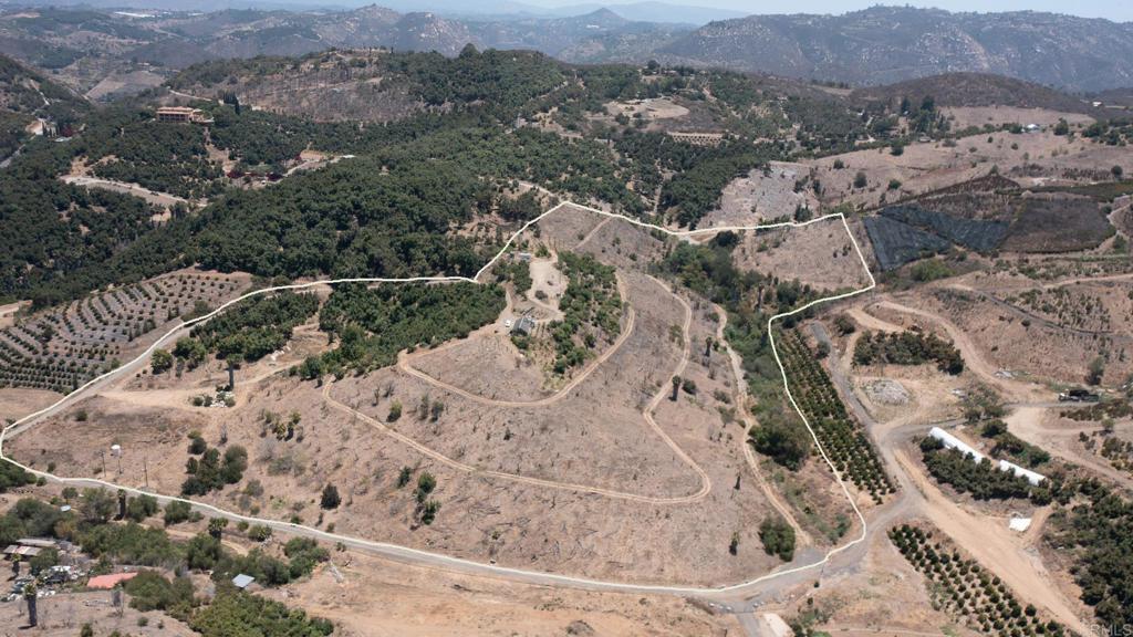
Gopher Canyon Road
DdirtVista, CA 92084
Lot Size
25.96 acres
Asking $/Acre
$100,154
Days on Market
129
Property Type
Land
HOA/mo
N/A
MLS ID
NDP2606449
This property is in Vista (92084). View the Vista land market →
About This Property
Own your own piece of paradise in the rolling hills of Gopher Canyon. This exceptional offering includes two parcels totaling 25.96 acres, creating a rare opportunity to enjoy the beauty, privacy, and potential of a thriving organic avocado grove. Surrounded by a nature reserve, the property offers a peaceful and secluded setting with breathtaking panoramic views from multiple vantage points throughout the orchard. Build your dream custom home atop the hills and wake up each day to sweeping vistas and the tranquility of country living. The organic Hass avocado grove, comprised of over 1000 trees, is complemented by a variety of mature fruit trees, including 128 Cherimoya trees and 34 Longan trees, offering both agricultural potential and natural beauty. Conveniently located near Interstate 15, the property provides the perfect balance of privacy and accessibility. Well-equipped for future development and agricultural use, the property includes two water meters, two electrical meters, and two wells. Whether you're looking to create a private estate, expand an agricultural venture, or invest in a unique piece of North San Diego County, this remarkable property offers endless possibilities.
Location
Loading map...
What a Buyer Will Check
Caution: fire, hillsideAbout 17.5 acres of farm land on Gopher Canyon Rd, county land with a Vista address, zoned RR, rural residential, 4-acre minimum lot. Part of it slopes: lidar puts the median slope at 22%, with 29% of it over 25%, and the soil survey calls it very fine sandy loam, well drained, very limited for houses. It sits outside the flood zone, in a Very High fire zone. No public road frontage was found. Water comes from Rainbow Municipal Water District. Septic likely.
- Slopemedian 22%, 29% over 25%, about 12.5 acres under 25%USGS 1 m lidar
- Soilvery fine sandy loam, well drained, very limited for housesNRCS soil survey · Sep 11, 2026
- Floodzone X, minimalFEMA flood map · May 16, 2012
- FireVery HighCAL FIRE hazard zones
- Road frontageno public road frontage foundSanGIS rights of way · Nov 3, 2026
- ZoningRR, rural residential, 4-acre minimum lotCounty of San Diego zoning · Apr 7, 2026
- Homes allowedabout 1 (1 per 10 acres)County of San Diego zoning · Apr 7, 2026
- WaterRainbow Municipal Water DistrictSANDAG water districts
- Sewerseptic likelyCounty sewer and septic screening · May 7, 2025
- Coastal ZoneoutsideSANDAG coastal zone
- Farm contractno farm contractCounty farm contracts
- Elevation678 ft, 611 to 753 ft across the lotUSGS 1 m lidar
From FEMA, USGS lidar, the USDA soil survey, CAL FIRE, SANDAG and county and city zoning, checked Nov 7, 2026. Public records, not a survey: confirm with the city or county before you buy.
Want to know more about this land or have questions?
Zoned Schools
Elementary
Bonsall Elementary · grades K-5 · Bonsall Unified
Middle
Norman L. Sullivan Middle · grades 6-8 · Bonsall Unified
High
Bonsall High · grades 9-12 · Bonsall Unified
The district's assigned schools for this parcel, from its attendance boundaries and rules. Boundaries change: confirm with the district before you buy.
- Lot size
- 25.96 acres
- Asking $/acre
- $100,154
- County median $/acre (sold)
- $8,209county-wide
- Comp-implied value
- $1,018,035
Benchmarked against 2,886 sold-land comps (5-yr, recency-weighted) via zip price-size model · high confidence. Land value is site-specific — zoning, utilities, access, and buildability are not modeled. Not an appraisal.