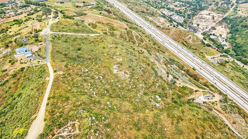
Aquaduct Road
AdirtBonsall, CA 92003
Lot Size
36.78 acres
Asking $/Acre
$7,477
Days on Market
522
Property Type
Land
HOA/mo
N/A
MLS ID
SW25117702
This property is in Bonsall (92003). View the Bonsall land market →
About This Property
**2 parcels available for sale equaling 40 acres.** Welcome to the charming community of Bonsall, California. Nestled in the picturesque landscapes of North San Diego County, this enchanting town offers a perfect blend of modern conveniences and the cozy ambiance of a small town. Immerse yourself in the tranquility of Bonsall as you explore the extraordinary opportunities that await. This remarkable property is awaiting an astute buyer to bring their vision to life. Whether you dream of creating an exquisite estate, establishing a flourishing farm, or preserving the entirety of this expansive land as a private retreat, the possibilities are truly endless. Each lot offers incredible views that showcase the natural beauty of the surrounding area, providing a mesmerizing backdrop to your future endeavors. Additionally, the convenience of nearby utilities ensures a seamless integration of modern amenities into your plans. Highly rated Bonsall schools! Water & electric are nearby, not on the land yet. Majority of land is on the slope side facing the 15 freeway if you were on Aquaduct road (Off of Highway 395 to Via Urner to Aquaduct Rd.) For questions regarding specific land use contact sandiegocounty.gov
Location
Loading map...
What a Buyer Will Check
Caution: fire, hillsideAbout 36.6 acres of vacant residential land on Aquaduct Rd, county land with a San Diego address, zoned A70, limited agriculture, 2-acre minimum lot. The zoning allows about 4 homes (1 per 8 acres on this slope). Most of it is steep: lidar puts the median slope at 32%, with 74% of it over 25%, and the soil survey calls it cieneba-rock outcrop complex, somewhat excessively drained, very limited for houses. It sits outside the flood zone, in a Very High fire zone. No public road frontage was found.
- Slopemedian 32%, 74% over 25%, about 9.5 acres under 25%USGS 1 m lidar
- Soilcieneba-rock outcrop complex, somewhat excessively drained, very limited for housesNRCS soil survey · Sep 11, 2026
- Floodzone X, minimalFEMA flood map · May 16, 2012
- FireVery HighCAL FIRE hazard zones
- Road frontageno public road frontage foundSanGIS rights of way · Nov 3, 2026
- ZoningA70, limited agriculture, 2-acre minimum lotCounty of San Diego zoning · Apr 7, 2026
- Homes allowedabout 4 (1 per 8 acres on this slope)County of San Diego zoning · Apr 7, 2026
- WaterRainbow Municipal Water DistrictSANDAG water districts
- SewerUnknown: no answer in the public recordCounty sewer and septic screening · May 7, 2025
- Coastal ZoneoutsideSANDAG coastal zone
- Farm contractno farm contractCounty farm contracts
- Elevation650 ft, 378 to 796 ft across the lotUSGS 1 m lidar
From FEMA, USGS lidar, the USDA soil survey, CAL FIRE, SANDAG and county and city zoning, checked Nov 7, 2026. Public records, not a survey: confirm with the city or county before you buy.
Want to know more about this land or have questions?
Zoned Schools
Elementary
Bonsall Elementary · grades K-5 · Bonsall Unified
Middle
Norman L. Sullivan Middle · grades 6-8 · Bonsall Unified
High
Bonsall High · grades 9-12 · Bonsall Unified
The district's assigned schools for this parcel, from its attendance boundaries and rules. Boundaries change: confirm with the district before you buy.
- Lot size
- 36.78 acres
- Asking $/acre
- $7,477
- County median $/acre (sold)
- $8,209county-wide
- Comp-implied value
- $659,860
Benchmarked against 2,889 sold-land comps (5-yr, recency-weighted) via zip price-size model · high confidence. Land value is site-specific — zoning, utilities, access, and buildability are not modeled. Not an appraisal.