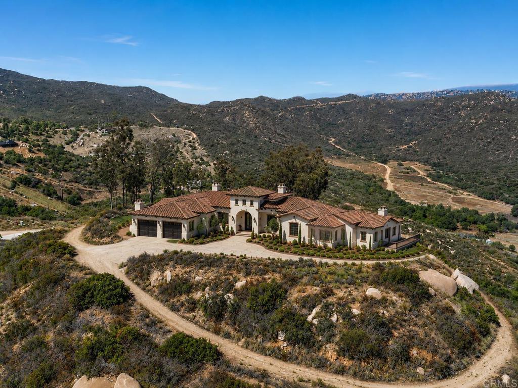
3020 Lynn Lane
AdirtSan Marcos, CA 92069Neighborhood: Twin Oaks Valley
Lot Size
28.72 acres
Asking $/Acre
$69,603
Days on Market
142
Property Type
Land
HOA/mo
N/A
MLS ID
NDP2605826
This property is in San Marcos (92069). View the San Marcos land market →
About This Property
Developers and multi-generational families, don't miss this rare 31+ acre mountaintop opportunity in San Marcos. Significant infrastructure is already in place, including a producing private well, water meters, electrical service with poles installed, paved access roads, multiple entry points, graded building pads, and over $1 million in seller improvements. A previous residence existed on the property, but there are currently no homes on site. Comprised of two parcels totaling over 31 acres, this private estate offers breathtaking ocean views, panoramic valley vistas, and exceptional privacy. Zoned A70 with the desirable "L" Animal Designator, the property may offer the potential for up to seven estate-sized homesites (buyer to verify). The seller is actively pursuing building plan approvals and anticipates approval soon, with septic installation planned in the near future. Whether you're envisioning a luxury estate, family compound, agricultural operation, or future development project, this property offers a rare combination of views, infrastructure, and opportunity in one of North County's most desirable rural settings.
Location
Loading map...
What a Buyer Will Check
Caution: fire, hillsideAbout 28.3 acres of rural acreage on Joni Ln, county land with a San Marcos address, zoned A70, limited agriculture, 4-acre minimum lot. The zoning allows about 2 homes (1 per 10 acres). Part of it slopes: lidar puts the median slope at 25%, with 46% of it over 25%, and the soil survey calls it cieneba-rock outcrop complex, somewhat excessively drained, very limited for houses. It sits outside the flood zone, in a Very High fire zone. No public road frontage was found.
- Slopemedian 25%, 46% over 25%, about 15.3 acres under 25%USGS 1 m lidar
- Soilcieneba-rock outcrop complex, somewhat excessively drained, very limited for housesNRCS soil survey · Sep 11, 2026
- Floodzone X, minimalFEMA flood map · May 16, 2012
- FireVery HighCAL FIRE hazard zones
- Road frontageno public road frontage foundSanGIS rights of way · Nov 3, 2026
- ZoningA70, limited agriculture, 4-acre minimum lotCounty of San Diego zoning · Apr 7, 2026
- Homes allowedabout 2 (1 per 10 acres)County of San Diego zoning · Apr 7, 2026
- WaterVallecitos County Water DistrictSANDAG water districts
- SewersepticCounty sewer and septic screening · May 7, 2025
- Coastal ZoneoutsideSANDAG coastal zone
- Farm contractno farm contractCounty farm contracts
- Elevation1,115 ft, 993 to 1,187 ft across the lotUSGS 1 m lidar
From FEMA, USGS lidar, the USDA soil survey, CAL FIRE, SANDAG and county and city zoning, checked Nov 7, 2026. Public records, not a survey: confirm with the city or county before you buy.
Want to know more about this land or have questions?
Zoned Schools
Elementary
Twin Oaks Elementary · grades K-5 · San Marcos Unified
Middle
Woodland Park Middle · grades 6-8 · San Marcos Unified
High
Mission Hills High · grades 9-12 · San Marcos Unified
The district's assigned schools for this parcel, from its attendance boundaries and rules. Boundaries change: confirm with the district before you buy.
- Lot size
- 28.72 acres
- Asking $/acre
- $69,603
- County median $/acre (sold)
- $8,209county-wide
- Comp-implied value
- $2,441,200
Benchmarked against 2,889 sold-land comps (5-yr, recency-weighted) via adjacent acreage band, same zip · low confidence. Land value is site-specific — zoning, utilities, access, and buildability are not modeled. Not an appraisal.