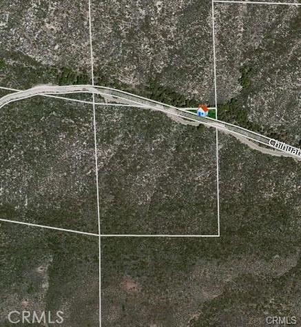
1 Chihuahua Valley
AdirtWarner Springs, CA 92086
Lot Size
33.59 acres
Asking $/Acre
$5,895
Days on Market
2
Property Type
Land
HOA/mo
N/A
MLS ID
IV26239987
This property is in Warner Springs (92086). View the Warner Springs land market →
About This Property
33.59 acres of undeveloped land in the Chihuahua Valley area of Warner Springs, in unincorporated San Diego County. APN 116-010-29-00. Zoned A70 per county records. Access is by a recorded 20-foot road easement across the neighboring parcel to Chihuahua Valley Rd. The land is raw: no known utilities, well, or septic on site, so a buyer should plan for a private well, septic system, and utility connections. No HOA. Buyer to verify zoning, permitted uses, legal access, utilities, water, and development potential with San Diego County, and to obtain any reports at buyer's expense. Drive direct to view; see directions.
Location
Loading map...
What a Buyer Will Check
Caution: fire, hillsideAbout 31.3 acres of rural acreage on Chihuahua Valley Rd, county land with a Warner Springs address, zoned A70, limited agriculture, 8-acre minimum lot. Most of it is steep: lidar puts the median slope at 28%, with 57% of it over 25%. It sits in a Very High fire zone; the flood zone is unknown. It has 1,079 ft of public street frontage on Chihuahua Valley Rd. No water district, a well would be needed. Sewer is unknown.
- Slopemedian 28%, 57% over 25%, about 13.5 acres under 25%USGS 1 m lidar
- SoilUnknown: no answer in the public recordNRCS soil survey
- Floodzone D, flood risk not studiedFEMA flood map · May 16, 2012
- FireVery HighCAL FIRE hazard zones
- Road frontage1,079 ft on Chihuahua Valley RdSanGIS rights of way · Nov 3, 2026
- ZoningA70, limited agriculture, 8-acre minimum lotCounty of San Diego zoning · Apr 7, 2026
- Homes allowedabout 1 (1 per 80 acres, on the ground under 25% slope)County of San Diego zoning · Apr 7, 2026
- Waterno water district, a well would be neededSANDAG water districts
- SewerUnknown: no answer in the public recordCounty sewer and septic screening · May 7, 2025
- Coastal ZoneoutsideSANDAG coastal zone
- Farm contractno farm contractCounty farm contracts
- Elevation3,828 ft, 3,630 to 3,980 ft across the lotUSGS 1 m lidar
From FEMA, USGS lidar, the USDA soil survey, CAL FIRE, SANDAG and county and city zoning, checked Nov 12, 2026. Public records, not a survey: confirm with the city or county before you buy.
Want to know more about this land or have questions?
Zoned Schools
Elementary
Warner Elementary · grades K-6 · Warner Unified
Middle
Warner Junior/Senior High · grades 7-12 · Warner Unified
High
Warner Junior/Senior High · grades 7-12 · Warner Unified
The district's assigned schools for this parcel, from its attendance boundaries and rules. Boundaries change: confirm with the district before you buy.
- Lot size
- 33.59 acres
- Asking $/acre
- $5,895
- Zip median $/acre (sold)
- $6,137
- Comp-implied value
- $233,833
Benchmarked against 2,886 sold-land comps (5-yr, recency-weighted) via zip price-size model · high confidence. Land value is site-specific — zoning, utilities, access, and buildability are not modeled. Not an appraisal.